Showing posts with label Maps. Show all posts

20090528

The Mediterranean Sea and Barcelona Airport

Click to enlarge:
Left is Barcelona
To the right is Salou coastline just 70 minutes south.
The Train ride which was to be one hour was an hour and half.


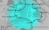
Here is the entire circle that we took. Starting on the left sailing out of Barcelona, we headed up northward to France then over to Italy and then down to Palermo. At the bottom of the map you see to top of Africa which is Tunisia and then over to the island of Palma De Mallorca and back to Barcelona.

20090523

The Cannes Port City

Click once to enlarge:


You can see the area that the ships pull into in the middle of the map.

20090519

Map of Liverno and Civitavecchia, Italy

Our Tuscan Drive left the port of Livorno upward to the Monte Carlo area. The drive was graced with umbrella pine trees and marble laced hills. The little town you see about half way up is Piza with the famous bell tower.
The purple line at the bottom of the map on the left, shows the drive from Port Livorno, Italy up the highway where we could see the Leaning tower of Piza into the hills of Monte Carlo. To the South (or left) you can see how far away Rome is.
On the following day, we docked in Civitacecchia, Italy to drive to Rome.

20090428

Sicily, the Port of Palermo, Italy

See the island of Sicily at the lower right of the map. Click to enlarge:


20090427

Tunis, Tunisia

Click to Enlarge:


This very liberal Muslim country is on the most Northren tip of Africa. These people were the most friendly and the only country that accepted our American Dollar. All others required the Euro which valued our American dollar at seventy-five cents.